ICELAND - Jun 2015
15 Days 14 Nights
Self Drive Trip - 1 couple (4,000km plus one speeding ticket)
9 Jun 2015 - 23 Jun 2015
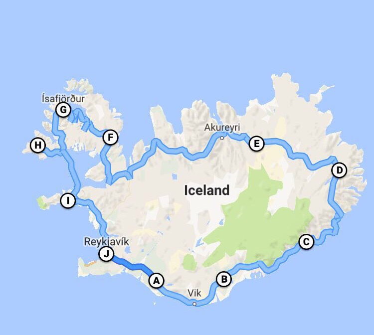
Map of our roadtrip: Reykjavik > Hvolsvöllur > Kirkjubæjarklaustur > Brunnhólskirkja > Egilsstaðir > Lake Mývatn > Skagafjörður > Hólmavík > Ísafjörður > Patreksfjörður > Snæfellsnes > Reykjavik
HOTELS
|
|
REYKJAVIK
We arrived Keflavik International Airport around 135pm from Dublin, and drove straight to the famous Blue Lagoon after picking up our car at the airport. Load up your own beer at the duty free shop in the airport before starting your tour because beers are expensive in town. We rented a Nissan Qashqai 4x4 from Arctic Car Rental for a total of 202,730 ISK (about SGD 2,268) for 14 days. The price included the delivery of the car to the airport, insurance for theft protection, gravel protection, SCDW, and a free GPS. The drive to Blue Lagoon is only 20 mins (23km). The first impression we had while driving on Iceland road is "wow", a totally different scenery from most of the countries we've been to. The entrance fee to the Blue Lagoon is not cheap compared to Japan's Onsen. The cheapest is 50 Euro (just the entrance fee and silica mud mask), which we opted. After soaking up for an hour, we felt energized and continue with our 40 mins drive to Reykjavik (49km) and spend the rest of the day exploring the city. Our lodging in Reykjavik was Rey Apartment for 174 Euro a night. |
|
|
REYKJAVIK > THINGVELLIR NATIONAL PARK > GREAT GEYSIR > GULLFOSS > KERID > RANGARVALLAVEGUR
Today, we traveled to some of the best known natural phenomena in Iceland on the “Golden Circle” route, starting with Þingvellir National Park, which is 35 mins drive from Reykjavik (40km). This a a place where you can actually walk in the rift valley between the North American and Eurasian tectonic plates. The water between the plates is super clear, and there's snorkeling activities here. From Þingvellir National Park, we drove about an hour (69km) to the Haukadalur geothermal area, home of the Great Geysir—the original “geyser”—and its more active neighbour, Strokkur, which spouts water every few minutes. We spend sometime here admiring the water shooting up every few minutes, where some could reach as high as 20-30m! Following that, we head to the majestic Gullfoss waterfall, which is just a short 10 mins drive away from the Geysir. Gullfoss waterfall is one of Iceland's most majestic waterfall, plunging 32m down into the canyon in two stages. We ended the day driving to the old implosion crater of Kerið (44 mins, 56km) before heading to our hotel for the day, Hotel Selid, located at Rangárvallavegur (about an hour drive, 69km). There's a small entrance fees of 400 ISK to see Kerið. We stayed in Hotel Selid for 158 Euro a night. |
|
|
RANGARVALLAVEGUR > SELJALANDSFOSS WATERFALL > SKOGAFOSS WATERFALL > SOLHEIMASANDUR AIRPLANE WRETCHAGE > MYRDALSJOKULL > KIRKJUBAEJARKLAUSTUR
After breakfast, we make our way to the south coast and visit the majestic Seljalandsfoss waterfall—where you can walk right behind the misty cascade. The drive took us about 30 mins (36km). Do spend time in the other waterfall nearby, Gljúfurárfoss, which can be seen in all it’s splendour by wading the river into a narrow opening in the cliff or by climbing a steep path up the cliff. Do bring waterproof clothing as you are expected to get pretty wet even on a dry day. We headed further south (25 mins, 29km) after that to see the equally impressive Skógafoss waterfall. We climbed up to the top of the waterfall (there's a proper stairways up), and hike for about 2 hours as the view was amazing up there. The scenery reminds us about the Jurassic Park setting! From Skógafoss waterfall, we drove to the Sólheimasandur airplane wreckage, located between Skógafoss waterfall and the town of Vik. The road is into the wreckage is quite rough and a bigger car or 4x4 is recommended (though 2WD car also possible). Although the distance is not that far, we have to drive very slowly due to the rough road conditions. It took us almost 25-30 mins to reach the crashed plane site. Thereafter we drove to Vík (35 mins, 23km) and stop to admire the black volcanic beach and the dramatic Dyrhólaey and Reynisdrangar rock formations. Other sights on the way include the Mýrdalsjökull glacier and the quaint village of Kirkjubæjarklaustu, where we put up at Hotel Laki for 130 Euro a night. |
|
|
KIRKJUBAEJARKLAUSTUR > FJAORARGLJUFUR CANYON > KIRKJUGOLF > SVARTIFOSS WATERFALL > SVINAFELLSJOKULL GLACIER > HOFN
From the hotel, we set off to Fjaorargljufur Canyon, a gorgeous canyon formed 9,000 years ago. It was a short 15 mins drive from Hotel Laki (14km). The trail that walk alongside the canyon offers amazing craftsmanship of mother nature, and we would definitely recommend people to walk the trail. After that, we backtracked 13 mins (10km) to Kirkjugolf - The Church Floor - where you see the strange rock formations. Basalt columns eroded and shaped by weathers, glaciers, and the sea loo like a man-made tiled floor. From Kirkjugolf, we passed by the beautiful Skaftafell area of Vatnajökull National Park and headed to the beautiful Svartifoss waterfall (50 mins, 70km), which drops over a wide cliff of basalt columns. From the car park, we opted for the difficult trail that requires more than 1.5km of hiking to the waterfall. There is an easy trail (flatter ground) but requires to walk a longer distance. We hiked up further after seeing the waterfall to have a better view of the surrounding snow cap mountain and glaciers. After Svartifoss, we drove to the Svínafellsjökull Glacier, which is only 10 mins drive away (6.4km). The glacier is just a short walk from the car park. Here, we saw a few people doing the glacier walk, which requires a guide as it is dangerous to without one. We ended the day at Hofn area (53 mins, 70km), staying at Hali Country Hotel for 212 Euro a night. On the way to our hotel, however, we passed by the famous Jökulsárlón glacier lagoon. |
|
|
HOFN > JOKULSARLON GLACIER LAGOON > DJÚPIVOGUR > BORGARFJOROUR EYSTRI > EGILSSTAOIR
Today, we backtracked to visit Iceland’s most famous attractions and top photo spots, the Jökulsárlón glacier lagoon, (10 mins, 14km) where we took the boat ride among the floating icebergs and curious seals. James Bond also filmed one of the scenes in 'Die Another Day' , and we heard from our guide that they crashed 3 Aston Martins here. Afterwards, we begun the zigzagging journey along the East Fjords, making a brief stop at Djupivogur, which is slightly more than 2 hrs drive (173km). Djúpivogur is a charming village with a long history of trading since 1589 located in a place of incomparable natural beauty. Today the main industry is fishing with tourism increasing rapidly in recent years. The pyramid-shaped Búlandstindur at 1069 m, dominates the landscape, and according to legend it can make wishes come true during the summer solstice. From Djúpivogur, we make our way to Borgarfjorour Eystri, which is 2 hrs 30 mins drive away (155km). We have to drive on gravel road on some part of the journey, but its worth the drive to watch the puffins up close and personal. During late-April to mid-August, about 10,000 puffins nest in the area and you get close to them from the observation platform by the Borgarfjorour Marina. There are also other type of birds in that area during this period. The changing landscape of this long drive is also amazing, from lava field to snow cap mountains. After watching the puffins, we drove slightly more than an hour (70km) to our hotel at Egilsstaoir, Hotel Valaskjalf (136 Euro a night), and ended the long day. |
|
|
EGILSSTAOIR > LAKE LAGARFLJOT > NAMASKARO PASS > VITI CRATER > LAKE MYVATN
After breakfast, we left Hotel Valaskjalf to visit Lake Lagarfljot (15 mins, 16km). The lake is said to be home to the Loch Ness of Iceland, Lagarfljot-sormurinn or the "lake worm" (but we did not see any). Following that, we headed to the Lake Mývatn area. The first stop was Námaskarð Pass, which is 2 hrs away (174km). Námaskarð Pass is an area of geothermal activity and offers boiling mud pools in various colours and amazing surroundings. The smell from the area is pretty distinct due to the sulphur released from the mud pools. From Námaskarð Pass, we drove about 15 mins to Viti Crater near Krafla. This is a large crater approximately 300m in diameter whose name signifies Hell. It was formed during a 5-year long explosive eruption of the west side of Krafla at the beginning of the Myvatn Fires in 1724. The crater is filled with blue water (still frozen when we were there) and surrounded by a geothermal area and colorful mountains. We went round the crater, which is quite an easy walk before checking into our hotel, Dimmuborgir Guesthouse (167 Euro a night), at Lake Myvatn. Be prepared to see LOTS of flies as Lake Myvatn means Lake of flies!!! We took a short break in our hotel room and booked a whale watching cruise for the evening at Husavik through the hotel reception. The drive from the hotel to Husavik took about 50 mins (60km), and we joined the North Sailing for the whale watching activity (10,500 ISK each). Before we boarded the cruise, the staff told me that there was high chance of seeing both the humpback and blue fin whales today, and did!!! We saw a few humpback whales, and two blue fin whales for the trip :). After that, we head back to our hotel at Lake Myvatn. |
|
|
LAKE MYVATN > DIMMUBORGIR > DETTIFOSS > SELFOSS > ASBYRGI CANYON > LAKE MYVATN
We checked out from Dimmuborgir Guesthouse, and drive to the nearby Dimmuborgir to see lava formations (3-5 mins away). There are a few well-marked hiking trails ideal for a 15 to 40 mins spooky hike. The most popular hiking trail is called the church path, which leads you to a lava tube open at both ends with a dome inside called the church. Next, we drove to Dettifoss (47min 57km), the most powerful waterfall in Europe. Dettifoss can be reached by a new tarmac road (Route 862, finished in 2011) and an older gravel road (Route 864). We opted route 864 to the west bank, where there are no facilities. Although the waterfall is somewhat hindered by the waterfall's spray, we were able to get really close to the waterfall as the snow has mostly melted. The east bank has an information panel maintained by the staff of Vatnajökull National Park (Vatnajökulsþjóðgarður) and a maintained track to the best viewpoints, as well as public restroom. However, the snow has not melted and hence the track was not opened. From Dettifoss, we walked further in to the other waterfall, Selfoss. After the 2 waterfalls, we continue with our drive through the Jökulsárgljúfur part of Vatnajökull National Park and visited the Ásbyrgi Canyon. The canyon is about 1km across and 3.5km in length with walls that are up to 100ms high. We did not hike up to the canyon, and headed back to Lake Myvatn area to check into another hotel, Vogahraun Guesthouse (180 Euro a night). |
|
|
LAKE MYVATN > GODAFOSS > AKUREYRI > SKAGAFJOROUR > SAUDARKROKUR
From the hotel, our first stop was Goðafoss ("waterfall of the gods"), 40mins 51km drive. This is an impressive waterfall by the main highway where a historical event took place in the year 1,000 when Icelanders converted to Christianity. We continue our drive towards Akureyri (43mins 53km), a charming town with a variety of interesting shops and museums as well as one of the world's northernmost botanical gardens. We had our lunch there, and I've tried the whale steak. The texture is quite similar to beef steak, but the after taste is a bit like pig liver in my view. After Akureyri, we continued towards Skagafjörður, a valley known for its abundance of Icelandic horses. We also passed through the beautiful, mountainous area of Tröllaskagi (“peninsula of the trolls”), the old herring-fishing village of Siglufjörður and Hofsós, where we stopped for a short break (with beers bought from duty free when we touched down). Thereafter, we make our way to our hotel for the night, Hotel Tindastoll (206 Euro a night), which is located at Sauðárkrókur. |
|
|
SAUDARKROKUR > GLAUMBAER > HOLMAVIK
From Sauðárkrókur, we make our way to Glaumbær folk museum, which is an old turf farmhouse in the North. Thereafter, we continue our drive towards the tranquil, remote West Fjords of Iceland. Sights along the way include the countless mounds of Vatnsdalshólar, the Borgarvirki natural fortress, and more Icelandic horses. We arrived Hólmavík, where we stay at Finna Hotel for 170 Euro a night. We passed by the Icelandic Sorcery and Witchcraft Museum and the Sorcerer’s Cottage, both in Hólmavik. However, we did not stop and visit these two places as we were not too keen on museums. |
|
|
HOMAVIK > ISAFJOROUR > SUDUREYRI
Today’s journey is characterized by endless but dramatic fjords and towering mountains on our way to Suðureyri , passing by Ísafjörður, the “Capital of the West Fjords” and the biggest settlement in the region. Here you‘ll find some of the most historic houses in Iceland, dating back to the mid-18th century. The scenery is just amazing, driving through the mountains and fjords. Some of the mountain road are still covered with snow and not passable for cars. The drive from Holmavik to Suðureyri will take more than 3 hours (241km) without stopping, which is impossible. You will definitely stop along the way to admire the beautiful scenery, just like us :) After many photo shots along the way, we arrived our hotel at Suðureyri, which is a small Icelandic fishing village perched on the tip of the 13 km-long Súgandafjörður in the Westfjords. The community was isolated for years by the huge mountains and rough road that led over them. Now it is connected to Ísafjörður by a 5 km tunnel. Our accommodation here is at Comfy Guesthouse (115 Euro a night). |
|
|
SUDUREYRI > DYNJANDI WATERFALL > LATRABJARG > PATREKSFJOROUR
After breakfast, we drove around Suðureyri, before heading towards the impressive Dynjandi waterfall, passing by Þingeyri. Like in most other seaside villages in Iceland, the culture and industry has been shaped by the sea throughout the centuries. Þingeyri provides various services to the surrounding countryside as well as to its visitors; a small shop, post office, bank and a swimming pool at the local sports hall. Before arriving Dynjandi waterfall, we drove passed the mountain road, where the height of the snow piled up was few meters tall. Reminds me of the Alpine route in Japan :) We had our packed sandwich lunch here before hiking up to the waterfall. The drive from Suðureyri to Dynjandi waterfall took more than 1 hr 30 mins (93km), excluding stopping time for photo taking along the way and in Þingeyri. Afterwards, we head towards the spectacular 444 metre-high cliff of Látrabjarg (2 hr 50 mins, 144km), the westernmost point of Europe. Here, you can get a good look at some of Iceland’s many species of nesting seabirds, such as puffins and razorbills up close and personal. You can literally touch the puffins!!! However, please be warned that the road to Látrabjarg is quite rough and mostly gavel road. We were fortunate as the weather was clear, and thus making our driving there easier and safer :) Thanks to the long day, we can enjoy more time at Látrabjarg watching the birds and amazing cliff. However visitors need to be careful since the cliff edges can be weak due to the nest of the puffins. We stay at Guesthouse Breidavik (192 Euro a night), Patreksfjorour, which is only 20-25 mins away (13km). |
|
|
PATREKSFJOROUR > RAUðISANDUR > VEGAMOT
Today, we started the day with a visit to the golden sands of Rauðisandur (red sand), where we need to drive via some 'dangerous' cliff road, similar to Látrabjarg. Rauðisandur is about 10km stretch of beach with unique colours sands that, depending on daylight and weather, can vary from white to yellow to red. The surface is not actually sand, but rather different sized chips of seashells. Our original plan after Rauðisandur was to take the Baldur ferry across Breiðafjörður Bay to the village of Stykkishólmur on the Snæfellsnes peninsula. Unfortunately, we were late and the ferry has left when we arrived. Hence, we decided to drive over to Snæfellsnes peninsula instead of waiting for the next ferry. The drive took us more than 4 hours with a total distance of 325km. After checking into our hotel (Hotel Rjukandi, 173 Euro a night) at Vegamot, we drove 15 mins (20km) to the Ytri Tunga for seal watching near the beach. We spotted quite a number of them, with some sun bathing on the beach and some swimming in the water. After that we drove further west towards the the Snæfellsjökull glacier in Snæfellsjökull National Park, and visited Raudfeldar Canyon (20-25 mins 30km) before heading back to hotel (40 mins). |
|
|
VEGAMOT > DEILDARTUNGUHVER > HRAUNFOSSAR WATERFALLS > REYKJAVIK
After breakfast, we drove about an hour (98km) towards Deildartunguhver, the largest hot spring in Europe, located in the lush valley of Borgarfjorour. This hot spring yield up to 200 litres per second of 100 degree celsius. We did not find this place really impressive and would not recommending a detour here. Further along, we made a stop at the beautiful Hraunfossar and Barnafoss waterfalls, which is a short 20 mins drive away. After that, we make our way to Reykjavik for our last two nights in Iceland, stopping by at Akranes to see the lighthouse (slightly more than 1 hour drive, 89km). The drive from Akranes to Reykjavik was only 40 mins, using the tolled bridge. We stayed at Aros B&B (290 Euro for two nights) in Reykjavik, which is a short driving distance to the city centre via the coastal way. |
|
|
REYKJAVIK > REYKJANES PENINSULA > REYKJAVIK
Our original plan was to join the tour that brings us inside an extinct volcanoes, but unfortunately, it was fully booked. Hence, we decided to drive to around the Reykjanes Peninsula, which is the direction towards Keflavik International Airport. Our first stop was Kleifarvatn, which is the largest lake of the Reykjanes Peninsula and one of the deepest in the country. On our way, however, we saw people hanging dried haddock and wolf fish and took some photos :). Unfortunately, when we arrived at the lake, it was too foggy to see much. So we continued our drive to Seltun. Here, there's a boardwalk leads through the area, where you can see many mud pots and fumaroles and mineral deposited from geothermal solutions provide colourful sediments. Next, we drove to Hafnarberg, a low, sheer cliff. Hafnarberg is a long line of sheer sea lava cliffs south of the old fishing hamlet of Hafnir. It is very popular among hikers and bird watchers as various marine birds nest at the cliffs. We head to Gunnuhver next, a collection of mud pools and steam vents sprouting from the ground surface near Reykjanes. Legend has it that Gunnuhver is haunted by a female ghost who was laid to rest here some 400 years ago. Nearby is the Reykjanesviti lighthouse. Few buildings in Iceland—or in the world—are as imposingly located as large steam clouds from geothermal fields at the bottom of the hill bring added drama to the surroundings. It was Iceland’s first lighthouse, and actually, there have been two versions of lighthouses with this name. The original one was built in 1878 but got severely damaged in a large earthquake that struck in 1887. The current version was built on safer ground in 1907 at Bæjarfell hill. Next we drove to the southwestern most tip of the Reykjanes peninsula where we can see the Eldey, a sheer 77 metre high rock protruding out of the sea. Our last stop was the "Bridge between continents". The Bridge between two continents at Sandvík is a small footbridge over a major fissure which provides clear evidence of the presence of a diverging plate margin. The bridge was built as a symbol for the connection between Europe and North America. Thereafter, we head back to Reykjavik and spend more time driving around the city and coastal area. It was an amazing driving trip for us and we felt that Iceland is like a big national park with interesting and ever changing landscape throughout our trip. |
