NORWAY - STAVANGER
21-26 July 2017
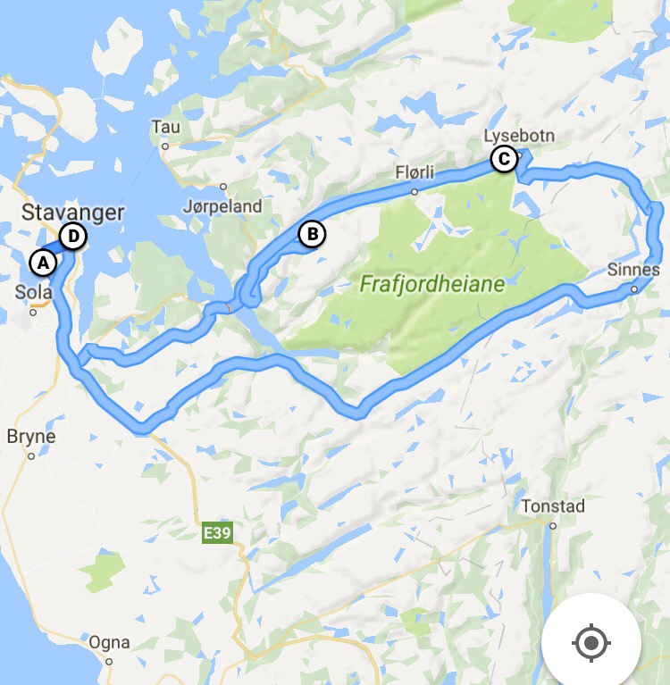
Map of our roadtrip:
|
|
Day 1 - Stavanger
We touched down in Stavanger airport at around 1015pm, and picked up our rental car from Sixt. We booked a Ford Fiesta through Rentalcars.com for SGD449, which included the full protection coverage. From the airport, it took us about 20-25 mins drive to our hotel. Checked in for the night, and getting ready for our hike to Pulpit Rock next morning. The hotel room, booked through Expedia.com, cost us about SGD99, inclusive of breakfast and free parking. Hotel Alstor |
|
|
Day 2 - Stavanager - Pulpit Rock
From Stavanger we took the car ferry to Tau, (142 kroner for a car up to 6 meters long plus 47 kroner per passenger one way) then drove from Tau to Preikestolen Mountain Lodge. We arrived at the carpark at around 11am and were back in the carpark around 5pm after we stopped at the top for about 2 hours to have lunch and enjoy the scenery. There are 2 steep parts of the walk and they are over rocks but the rest of the walk is fairly easy. Take some warm clothes with you so you can stop at the top and enjoy the view. It is 3.8 km in a straight line from the car park at Preikestolhytta to Pulpit Rock, but more like 6 km each way to walk. The car park is at 270m and the rock is 604 m above the sea. We opted another way back to Stavanger instead of through Tau. We drove to Oanes and took the ferry to Lauvvik (67 kroner for a car up to 6 meters long plus 28 kroner per passenger one way). From there, we drove to Dalsnuten to do another short hike (3.6km round trip). Took me about 1.5 hours in total, including some photo taking time up at the peak. After two tiring hikes, we headed back to Sverd I fjell (Swords in Rock), a suburb 14 mins drive from Stavanger. Then we walked through more than 15 years of Nuart Festival's impressive Street Art history and the evolution of Stavanger into one of the world's leading destinations for Street Art. Hotel Alstor |
|
|
Day 3 - Stavanger - Kjeragbolten Rock
Kjeragbotlen is located at the far end of the fjord so it took us about 3 hours drive from Stavanger. We drove there via Sirdal, which has very nice scenery. There are many small lakes formed by the melting ice. Though the region doesn't have high mountains as in Swiss, the plateau + the small lakes + super white melting ice is very charming. This is an impressive road in the high mountains of Rogaland and Vest Agder - highest point 932 metres - some of it single carriageway with passing places - with impressive scenery and weather. We arrived the carpark at around 1pm, and returned to the carpark at 8pm. The hike here is much steeper and harder and longer than the walk to pulpit rock but again the views are stunning. You need good weather or the trip is dangerous as you are walking on rock with a chain to help you get up and if the weather is bad there will be no view. We were fortunate that we were able to see the boulder and the fjord below when we arrived, and took some great photos. 10-15 mins later, the place started to rain and was quickly was filled with fog. Hotel Alstor |
|
|
Day 4 - Stavanger - Southern Stavanger region
After three consecutive hikes, we decided to take things easy and drive towards the southern part of Stavanger region instead of our original plan to do the Trolltunga hike (10-12 hours). Hotel Alstor |
|
|
Day 5 - Stavanger
After breakfast, we drove to Helleringstniner see the rock carvings from Viking days. Hotel Alstor |
TRIP PHOTOS - STAVANGER
